

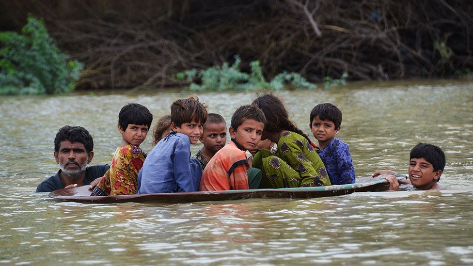
When torrential rain and cloudbursts overwhelm Islamabad and Rawalpindi this summer, the damage reached far beyond flooded roads. Water entered homes and shops, destroying belongings and interrupting livelihoods, and threatened lives. For families living near vulnerable drainage channels, a heavy downpour can become an emergency within hours. The recurring losses raise a difficult but necessary question: are our cities prepared for the rain they must now withstand?
The warning is recent. On September 1, 2026, rainfall figures reported from local authorities in Rawalpindi showed 201 millimeters at Shamsabad and 186 millimeters at New Kattarian. Lai water levels reached 29 feet at Kattarian and 23.5 feet at Gawalmandi, prompting evacuations as neighborhoods flooded.
Climate change is a major driver of the growing danger from extreme rainfall. A warmer atmosphere can hold more moisture, fuelling heavier downpours when conditions favour rain. The Intergovernmental Panel on Climate Change warns that further warming will intensify heavy precipitation, with increasing risks across South Asia. Our cities must therefore prepare for rainfall pressures that can exceed those anticipated by older infrastructure.

Urban development compounds that danger. Concrete and asphalt prevent water from soaking into the ground, sending it rapidly towards drains and streams. Encroached waterways, obstructed drains, and the loss of absorbent land can turn intense rainfall into destructive flooding. The efforts of planning and emergency agencies deserve recognition, but recurring damage suggests that drainage and land-use decisions need closer integration with a changing climate.
The Lai basin serves as a vital link between Islamabad and Rawalpindi. Water moving through upstream areas of Islamabad contributes to flows reaching Rawalpindi. Their administrative boundaries cannot separate this shared risk. Protecting communities downstream requires attention to how water is managed across the catchment.
A flood resilience model for Islamabad and Rawalpindi could link parks, civic squares, and planted corridors into a network that helps manage heavy rainfall. These spaces could temporarily store rainwater, slow runoff, and release it as downstream drainage capacity permits. This approach, known as blue-green infrastructure, brings water management together with vegetation and public-space design. Projects in Singapore and Rotterdam show how this principle works in practice and offer lessons that the twin cities could adapt to local conditions.
Consider a neighborhood park with a gently lowered central area. In dry weather, it serves as a place for recreation and community activities. Before hazardous rainfall, the lower area closes to visitors and temporarily receives runoff from nearby streets. Perimeter paths would be designed above the planned storage level, while a controlled outlet and a planned overflow route manage the water. After draining, cleaning, and inspection, the space returns to everyday use.
There are established examples. At Singapore’s Bishan–Ang Mo Kio Park, a concrete canal was transformed into a naturalized river. During dry weather, water follows a narrow stream. When rainfall raises the river, adjoining parkland provides additional space to carry water downstream. A landscape enjoyed by residents also performs a drainage function.
Rotterdam’s Benthemplein Water Square applies a similar principle at a smaller scale. Its sunken basins accommodate recreation when dry and collect stormwater when it rains. With a storage capacity of 1,800 cubic meters, equivalent to 1.8 million liters, it gives temporary rainwater storage a visible civic role. The design demonstrates how a public square can provide temporary storage within a built-up neighborhood.
The idea also has local roots. The Japan International Cooperation Agency’s 2003 Lai Basin study proposed a community pond in Fatima Jinnah Park to detain floodwater, alongside recreational uses. This was a planning proposal, but it shows that combining public space and flood storage has long been relevant to Islamabad.
For the twin cities, these lessons could inform a connected network of suitable parks and squares, supported by rain gardens, roof storage, and planted roadside channels. These spaces would manage local runoff, while larger river flows would retain a separate, continuous route. Such measures would complement drainage upgrades, protected waterways, and early warnings. Their value lies in managing some rainfall before it adds to pressure downstream.
Public safety and upkeep must shape the design. Storage areas need safe exits, clear warnings, and reliable maintenance. Sewage must be kept out of spaces intended to receive surface runoff. Coordination among the Capital Development Authority, Rawalpindi Development Authority, and relevant water and municipal agencies would help connect local interventions with the wider basin.
Climate change is increasing the urgency of adapting cities in the country. Islamabad and Rawalpindi have an opportunity to make public spaces part of that response, improving daily life while providing temporary stormwater storage. The proposed network deserves serious consideration within future planning and public investment. Each park renewal and neighborhood improvement offers a chance to reduce vulnerability before another downpour turns familiar streets into scenes of loss.

Sarim Ali : The writer is an architecture graduate of Istanbul Medipol University, Türkiye and based in Istanbul.

